This is documentation of an archived release.
For documentation on the current version, please check Knowledge Base.
For documentation on the current version, please check Knowledge Base.

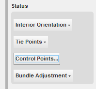
Control Points
|
In this status section, the function to edit the control points is available:
|
 Edit Control Points…
When selection this function, the following dialog is shown: It shows the existing set of control points in the project. Selecting a control point number in the list, shows the coördinate values in the bottom. Several functions are available and explained hereafter.
- Show
The selected control pôint will be centered in the Orbit GIS canvas.
- Add
A new Ground Control point can be added when you:- Enter a new point and it's coördinates,
- Press the 'Add' button.
- Modify
When a Ground Control Point (GCP) is selected, you can :- Change the name or the value of any coördinate.
- Press 'Modify'.
- Remove
This function obviously removes a selected GCP.
- Add file
 This function:
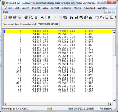
- Opens a File Selection Box
- Select a txt file containing GCP's.
- Press 'Open'.
The file will be checked on the correct format.
The syntax must be as follows (tab or space separated):
- Type
The GCP points can be either:- XYZ control points
- Z control points
This toggle lets you set the correct type for each control point.
- Control point is used
This is a flag telling the project to use a certain GCP or not, in the bundle adjustment process. When the toggle is flagged, the GCP is active.
Last modified:: 2019/03/25 11:36