For documentation on the current version, please check Knowledge Base.
Mobile Mapping Delivery
This page describes how to use the desktop mobile mapping extension “Delivery”.
The “Delivery” extension was created to give users the posibility to combine or split MM data, and export the results.
The export can be either in Orbit structure or a generic file-format.
![]() Main Toolbar > Extensions > Delivery
Main Toolbar > Extensions > Delivery
Concepts
Orbit Run
Make a delivery of a set of Orbit runs (from Catalog List) to combine them together into 1 Orbit run. During the processing of the delivery filtering of the pointcloud can be applied.
In some cases an export of a certain segment of an Orbit Run can be useful.
Export
Use the delivery extension to export your Orbit run(s) to an external format for use outside the Orbit software.
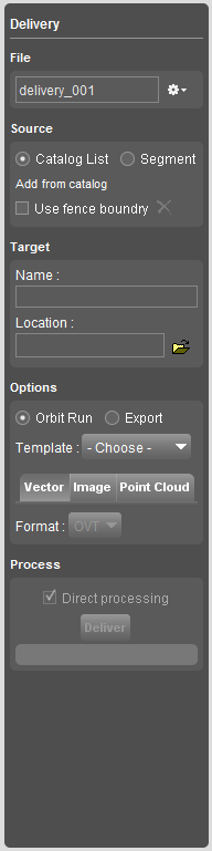
Sidebar
File
Make a new delivery, choose a recent or already existing delivery.
Close delivery to close the current settings. Edits will be saved on the fly.
Delete delivery to delete all the settings for the current delivery.
Source
Catalog list
Add runs from the catalog tab to the delivery. Optionally, use a fence to export just a segment of the run. To create a fence see: Create fence or add part
Segment
Select a segment on the map to use as selection of data to make a delivery.
Target
Insert the target folder name and choose a location to process the delivery
Options
Orbit Run
Choose an Orbit Mobile Mapping Template to define the output structure of your delivery.
Additionally output settings for the vector files, images and point cloud can be defined.
Export
Export the run into generic output-file.
Define the output settings for the vector files, images and point cloud
Process
Click Deliver to process the delivery to the target location.
The processing of the Delivery can be added to the Task Manager.