This is documentation of an archived release.
For documentation on the current version, please check Knowledge Base.
For documentation on the current version, please check Knowledge Base.
Orbit Mobile Mapping Publisher Update 11.0 - September 2014
Feature summary of the September 2014 update for Orbit Mobile Mapping Publisher.
The update is free of charge when having a valid software maintenance contract. For questions about this update, contact sales at orbitgt dot com.
The installation of this update requires assistance of the Orbit support team.
Server Side
New features
- New license mechanisms
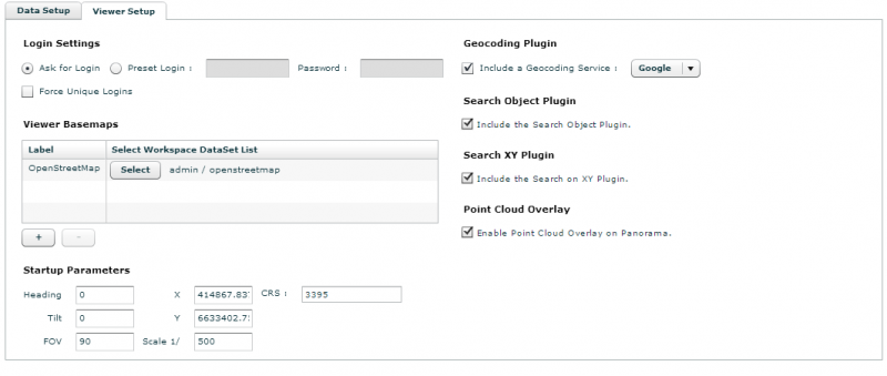
Version 11.0 introduces a new license mechanism for the Orbit MM Publisher based on the amount of concurrent users. The image throughput volume license remains available as well. - Restrict publication access to unique users
The administrator can protect a publication to be used on multiple hardware (client computers) using the same publication login (username). - Advanced logging system
The administrator can activate and configure advanced logging for the MM Publisher to get exact information about the use, publication access, user logins, concurrent sessions and throughput volume of the Publisher. - Real-time logging of server memory load
The server load table in the EOS console lists the real-time server memory consumption of each loaded resource. This overview is very useful in case of server memory issues. - Real-time blurring
Detected blur and erase regions can be applied on the fly. The administrator defines if the original images will be published with or without applying the blur definitions. Consequently one set of images (single storage!) can be made available for different group of users with or without blurring. - New legend parameters for vector overlays
New legend parameters are supported on vector overlays. The most important are these to define vector overlay labels on panoramas. All parameters are directly used from the Orbit legend, so it is not required anymore to redefine the vector overlay legend in the EOS Console.
Usabilities and enhancements
- Optimized used of server memory
A highly optimized used of active and inactive resources has been developed to publish enormous sets of mobile mapping data and geo-resources. - Preset project visibility
The administrator can pre-define the mobile mapping project visibility. This is very useful when combining multiple mobile mapping projects (e.g grouped by year) into one publication. The administrator can set the most recent year visible on start-up. Older projects can be made visible by the user if required. - Auto sync project label settings
The EOS console will sync all mobile mapping projects grouped by a label having the same color and visibility. - Various minor usabilities and bug fixes.
Panorama Component
New features
- Intelligent rendering on virtual environments
Orbit publishing Clients will use the 3D graphics card if available. If no 3D graphics card is available, a dedicated solutions is developed to optimize the use of a publishing clients on virtual environments. - Vector overlay selection
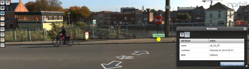
Any visible vector overlay object can be selected on the panorama component with a single click. The object will be highlighted on the panorama component and the object attribute values can be reviewed via the metadata window. - Vector overlay labels
Labels of vector overlays can be displayed on panoramas according the Orbit legend settings. Vector overlays are supported both for EOS resources and client-side WKT overlays. - Horizontal rectangular area measurement by 3 clicks
- Vertical rectangula area measurement by 2 clicks
- Image metadata
Using the panorama sidebar information icon the image metadata can be reviewed.
Usabilities and Enhancements
- Optimized method to open and add new views
Using the panorama component's open image function, already opened views can be replaced or a new view can be added. Click or click and drag, just that easy to meet user needs. - Optimized copy of measurements
Measure results can be copied with an id and tab separated ready to be pasted directly in your spreadsheets. - Optimized walk through
If a point cloud is available, a double click can be used to walk through the images. Combine with <Shift> to open and focus the nearest image. - Auto hide unsuccessful point cloud measurement message
If Orbit was not able to calculate the point cloud measurement the popup message will be hidden automatically after 2 seconds. - Open by photoId
The entire photoId [project]/[run]/[image] or the [image] tag only can be used as photoId to open a dedicated image. - Project window
Project window button is always available even if only one project label is used by the publication. Let say this is the legend display for your mobile mapping projects. - Various minor usabilities and bug fixes.
Map Component

New features
- Simplified trajectory
From map scale 1/5000 the simplified trajectory will be displayed. Photo positions will become available when using a larger scale. - Search on XY
The administrator can add a standard xy-search plugin to allow the user to search for a location and to open the nearest image using a XY coordinate.
Usabilities and enhancements
- Optimized search on Object attributes
The administrator can add a standard object-search plugin to allow the user to search for a location and to open the nearest image based on a dataset object attribute. - 6 basemaps
The maximum number basemaps increased from 3 to 6. - Center map on open publication at XY
When opening a publication at a requested XY coordinate the map will center accordingly - Refined map scale setting
When using geographical map coordinates (publication crs WGS84) the start-up map scale can be defined as decimal value to get the start-up map view you want. - Various minor usabilities and bug fixes.
API
- All new features and enhancements are available via API
- Complete WebClient API for Flex
- Methods added to enable follow focus and to focus of all opened viewers to the requested coordinate.
Previous updates
Last modified:: 2019/03/25 11:36