This is documentation of an archived release.
For documentation on the current version, please check Knowledge Base.
For documentation on the current version, please check Knowledge Base.
OSGB 1936 / British National Grid
EPSG : 27700
- Description : OSGB 1936 / British National Grid
- Type : Projected CRS
- Area : United Kingdom (UK) - Great Britain - England and Wales onshore, Scotland onshore and Western Isles nearshore; Isle of Man onshore.
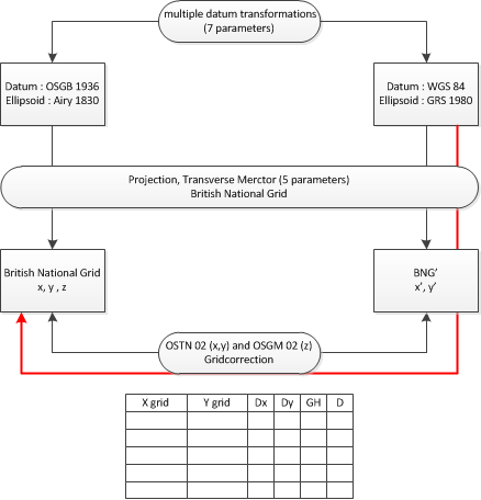
Since version 10.2 Orbit supports the OSGB 1936 / British National Grid as described by the Ordnance Survey.
Both OSTN02 xy and OSGM02 z grid corrections are implemented.
To use this implementation the Ordnance Survey grid file OSTN02_OSGM02_GB.bin (22MB) need to be available in the Orbit directory (program/system/crs).
Download, unzip and copy to the indicated directory : ostn02_osgm02_gb.zip.
More information about :
- the use and application of Coordinate Reference Systems in Orbit, see Coordinate Reference Systems in Orbit
- technical specifications of this coordinate system , read the available documentation on the Ordnance Survey website :
Last modified:: 2019/03/25 11:36